
The Roof of Europe
Dear M
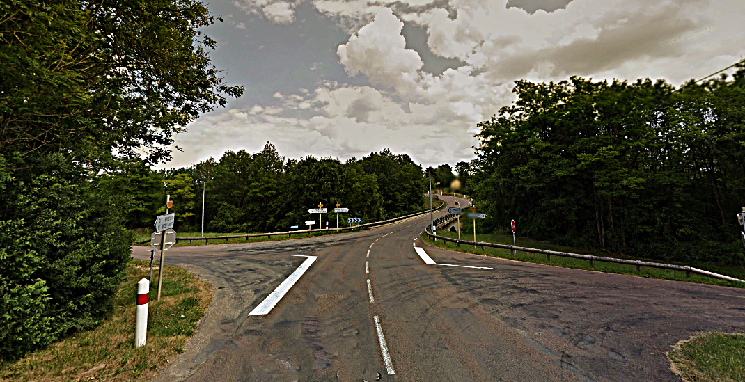
If you drive from Recey sur Ource to Dijon on the D959, after 16km, before you get to Grancey le Chateau, you come to this crossroads. Stop and get out of the car and look in the direction of Dijon straight ahead!
If it is raining while you are there the rain that falls behind you flows eventually into the North Sea or the Atlantic Ocean and the rain that falls in front of you goes into the Mediterranean sea. Stand at the crossroads and you are standing on "the roof of Europe" for this is the Continental Divide. Our own little bit of the European Watershed with it’s southern end near Gibralter and it’s northern end in the Russian Arctic
Interestingly, the man-made border between the Cote d"Or and the Haute Marne which is also the border between Grande Est and Bourgogne Franche-Comte at this point follows the Continental Divide.
The reason that the lady of Vix was near Vix when she died was because, I think, two-thousand five-hundred years ago she travelled by boat up the Rhone, up the Soane, up the Tille to somewhere near Is sur Tille the got out of the boat and walked up the valley of the Tille so she could cross the watershed at the lowest place and get into another boat which would take her to the Seine and so on to the far north and the far west of Europe.
It is to my mind, more than likely that she stood on or near this crossroads to have a rest and watched while her servants and companions walked slowly past carrying the vast and astonishing treasure of Vix. Imagine the Krater of Vix borne on the shoulders of men. As she looked backwards thinking of her Etruscan home far far away, she might have wept a little. She was, after all, alone, quite small and only a few years older than you. Then she turned round to march on to the wonders of the lands and peoples to the north and the west.
Why do I think she came this way and stopped at this point? She travelled with heavy baggage and this route allowed for more miles by water than any other. So if she took the route I describe - and better informed people than me say that many such travellers did - and she came up the valley of the Tille she would definitely have found, 2500 years ago, a fortified settlement where the Chateau at Grancey le Chateau now stands. She would have spent the night there for safety and comfort and the path that took her onwards in the morning would go on up to the pass across the watershed in the best and shortest way possible. You are now standing on that route, at that place which is "the top of the hill" and then as now those who get, at last, to the top of the hill paused and looked backwards and thought of their starting point before squaring their shoulders, drying their tears and walking on to whatever the future might hold.
Don't let anyone tell you that she went via Montbard, they don't know what they're talking about
Joe
~~~~~~~~~~~~~~~~~~~~~~~
This is part of an email to a young woman who had recently come to work for the administration of the Parc national de forêts. The administrators of the park, inscribed as a national park in 2019, were not best pleased with the author as they did not know that the European Watershed ran through their new park and they were covered in confusion when he suggested that it should be acknowledged and incorporated into the “story of the park”. Nor were they amused when he insisted that the trees in the Parc national de forêts. were an irrelevance and suggested that they change the name of the park to reflect the reality that it was the water and the drainage patterns and the watershed that defined everything that was special about the park.
The trees themselves which are, of course beautiful and numerous are neither rare nor threatened. They certainly attract visitors who like the idea of walking or riding benehath trees. But in the past they hampered movement, harboured bandits and were only useful for firewood and building. And they, of course, relied upon the supply of water to survive. The historic paths which carried pilgrims from Canterbury to Rome and on to the Holy Land passed ~ still passes ~ through the park by way of river valleys. The roads to the Crusades skirted the park in river valleys and mighty rivers including the Aube, the mighty Marne, and the Seine into which it flows near Paris, and the river system that starts as the Tille and becomes the Saone and then the Rhone and so into the Mediterranean Sea and other rivers that flow east into the basins of eastern Europe and central Asia and north to the arctic wastes all rise in or close to the Parc national de forêts.
The social history and modern social fabric of the area, the author said, depended on water. The pattern of settlements followed the water in the valleys, valleys formed by water. The people who lived in these settlements spent their lives managing water, water for farming, water for animals. water to drive machinery to do everything from make bread to making iron. Each village had in the centre a washouse where people and products were cleaned and round which the social life of the village revolved. These washouses are still there for the most part lovingly preserved. The saw mills, and iron foundries which were powered by water are on the edge of town or out of town altogether. The rare birds and the flora and fauna of the tuffa swamps, of which the park administration are rightfully proud, care little about the trees but rely on water for their very life.
The author’s suggestion that at least some of this and the presence of the watershed might be acknowledged and sewn into the story of the Parc national de forêts were rebuffed. It is of course a matter of opinion whether the people who ran the park or the author who thought his suggestions and his offer of support in kind and money would be welcomed were the most stupid.